 |
 |
The centuries - old mystery of El Dorado has been partially unveiled by the Chilean Roland Stevenson, a researcher living in Amazônia. Vestiges of El Dorado have been located in the extreme north of Brazil, more precisely in the State of Roraima and previous British Guiana. (Adaptad from Jornal
"Alternativo" do Meio Norte - Piauí) The first obstacle in their search for the lake of gold concerned its exact location. Could it be the Guatavita lake in Colombia as some traditions indicate? This lake was even partially drained by several explorers, but in tit no treasure was ever found. Many other places in South America were also considered to have been the lake and its city of gold. In Brazil, it has been called Manoa and would be situated somewhere in the Amazon jungle. The researcher Roland Stevenson* began with the historical fact that the Peruvian empire of the Incas, so rich in gold and silver handicrafts, possessed in their territory only mines of the latter metal. Gonzalo Pizarro, brother of Peru’s governor knew this and in 1541 he organized an expedition to search for the source of Inca’s gold. In fact, Pizarro was the first to speak of El Dorado place the Amazonian, in terms of a lake in his letters to the king of Spain. The first expeditionaires in search of gold headed for what is now Colombia, but they did not have information about El Dorado being located at the edge of a lake. Cieza de Leon, Fernandes de Oviedo, Benalcazar, the brothers Jeminez de Quesada, among other famous explorers of the time, make no mention of this detail in their reports.
In 1584, the spaniard Antonio de Berrio, left Tunja (Colombia) intending to explore the hinterland of the Guianas. The explorer believed that the mysterious El Dorado was located by a lake sorrounded by mountains. Berrio delived into the forest at the headwaters of the Orenoco and Caroni rivers, but he did not continue on to the region where the natives told him the Manoa lake was located, that is, on the other side of the language, Ma-noa means lake). The Parime name to emerge in four years ago. |
Although Raleigh made a sensation in Europe, proclaiming the riches of the Empire of Guiana, he himself never arrived anywhere near Roraima nor very far from the north of the Caroni river. The subordinates of Berrio and Raleigh, Domingo de Vera and Laurence Keymis, however, did reach "El Paso", where today the town of Santa helena in Venezuela is located. This town is near the border of Brazil where a lower area of the Pacaraima mountains permits passage. There the expeditionary’s were pleased to see the natives wearing gold ornaments but were unable to go forward because they were so few. Almost a century later, the race for gold management to the small lake Guatavita in Colombia, due to the story of the "Golden Man", which seems to have been only an excuse for the failures in Brazil. With the help of historical researchers, geologists, anthropologists and archeologists, Stevenson followed the vestiges of the extinct pre-Columbian road in the Uaupés basin and ended up in Roraima, there identifying what had been Manoa or Parime, the lake of "El Dorado". It now exists as a level area known as the palins of Boa Vista. This immense region does not have a continous cover, but only trees (buritis) at the margins of the lagoons, rivers and backwaters.
According to Stevenson, the Sacred City of Manoa probablement was located in the west region of the lake, just as was shown on the first expeditionaires maps. On Hariot’s map for example, Manoa is shown on the edge of the lake, behind an island. Its exact location would be west of what is called today Maracá Island. There, at the time when the lake was full, would have been the mouth of the Uraricuera river. On can only wait for future research to uncover the vestiges of the city of Manoa to see the El Dorado to left the realm of legend and enter into History. |

 According to Stevenson, exist the pre-Colombia
road was quite long, crossing part of Colombia and the entire north of Brazil, passing
through Roraima and ending on the Atlantic coast in Amapá. There some researchers have
discovered, for example, the Waiapi, speaking the ancient quechua language of Peru as do
the Taulipang in Roraima according to the linguist Migliazza, exact area large potential
of gold in Brazil. From this it appears that the question concerning the origin of the
Inca’s gold has been answered. Reinforcement of the argument came from the
archeological discovery of four stone weapons
According to Stevenson, exist the pre-Colombia
road was quite long, crossing part of Colombia and the entire north of Brazil, passing
through Roraima and ending on the Atlantic coast in Amapá. There some researchers have
discovered, for example, the Waiapi, speaking the ancient quechua language of Peru as do
the Taulipang in Roraima according to the linguist Migliazza, exact area large potential
of gold in Brazil. From this it appears that the question concerning the origin of the
Inca’s gold has been answered. Reinforcement of the argument came from the
archeological discovery of four stone weapons  called bordunas, having eight points and used to buy soldiers of
the Inca empire. The weapons were found in the gold-bearing areas of Roraima.
Stevenson’s bilingual book, "A Light on the Amazonian Mysteries" (Manaus
1994) is full arguments and proofs demonstrating inequivocally that one pre-Columbia road
existed.
called bordunas, having eight points and used to buy soldiers of
the Inca empire. The weapons were found in the gold-bearing areas of Roraima.
Stevenson’s bilingual book, "A Light on the Amazonian Mysteries" (Manaus
1994) is full arguments and proofs demonstrating inequivocally that one pre-Columbia road
existed.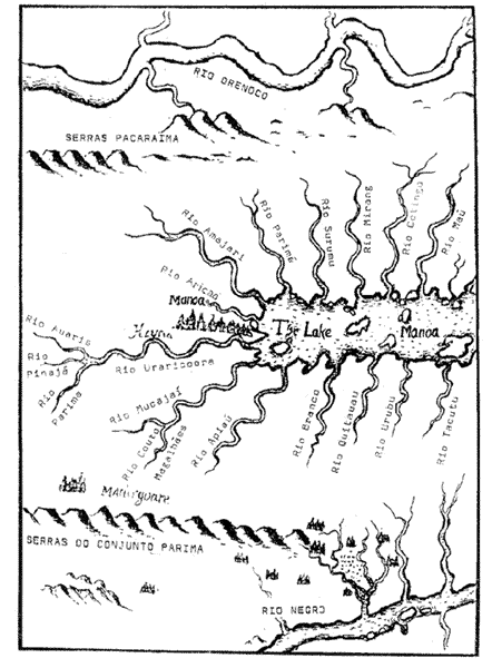
 Upon examining the region, Stevenson discovered that on all the
surrounding hillsides a horizontal line appears at a uniform level approximately 120
meters above sea level. This line registers the water level of the extinct lake which
existed until relatively recent times**. It was deduced that here was the legendary lake
located between Roraima and Briths Guyana. Its previous diameter measured 400 km and its
area 80,000 km2 (square kilometers). For researchers who studied it, the
lake’s extinction began only about 700 years ago, so that the Spanish conquerors were
contemporaries of the process.
Upon examining the region, Stevenson discovered that on all the
surrounding hillsides a horizontal line appears at a uniform level approximately 120
meters above sea level. This line registers the water level of the extinct lake which
existed until relatively recent times**. It was deduced that here was the legendary lake
located between Roraima and Briths Guyana. Its previous diameter measured 400 km and its
area 80,000 km2 (square kilometers). For researchers who studied it, the
lake’s extinction began only about 700 years ago, so that the Spanish conquerors were
contemporaries of the process.
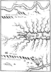 |
Map nş 1 Parime Lake or Manoa This is a detail of first map we know of concerning the Manoa lake and the city to its west (left). The map was drawn by the englishman, Thomas Hariot, in 1595 and has an incredible similarity with the hydrographical reality of Roraima, including the islands which have now become high points while the lake-bed has become plains of grass. We have written in the present-day names of the rivers. The map shows no juncture of the Branco river with the Negro river, but geologists tell us that a linkage between them caused the lake’s drainage, and other phenomena. |
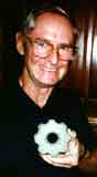
* Roland Stevenson discovererer of the legendary extinct lake in Roraima, shows on of the stone Incan Bordunas found in the gold-bearing areas throwing light on the centuries-old mystery of the peruvian civilization’s source of gold.
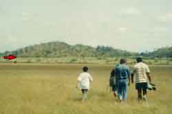
** Group of newspapermen examine vestiges of the lake, under the orientation of Gert Woeltje (center). The photo cleary shows mark of the water’s level on the slope (arrow red), the band that divides the vegetation into light and dark sections.
![]()